It’s not a common requirement in my experience, but it does come up every now and then: a customer is happy with a simple Report + Form but when they open a record, they want to be able to make their changes and go to the “next” record in one button click, instead of having to go back to the report and select the other record.
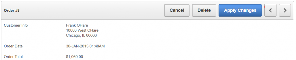
In the Sample Database Application, page 29 (Order Details) implements “Next” and “Previous” buttons which allow the user to save and open another record in one action.
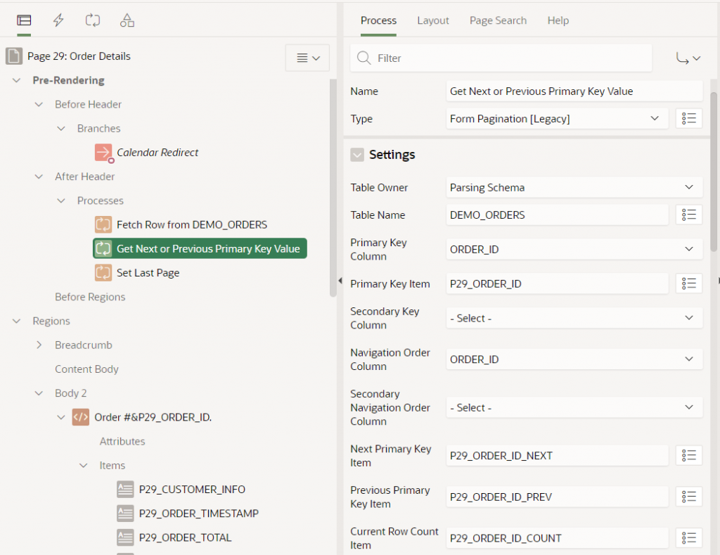
These buttons are implemented using a legacy Form Pagination process. This process sets some hidden items (P29_ORDER_ID_NEXT, P29_ORDER_ID_PREV, P29_ORDER_ID_COUNT) based on a query on a specified table (DEMO_ORDERS) with a specified unique identifier (ORDER_ID) associated with a primary key item (P29_ORDER_ID). The process requires a navigation order, specified by one or two columns (ORDER_ID, in this instance) in order to know what would the “next” and “previous” records be. If there is no next or previous record is found, the buttons are hidden.
When the page is submitted, the Next and Previous buttons submit a request (GET_NEXT_ORDER_ID or GET_PREVIOUS_ORDER_ID, respectively). After the ApplyMRU process has run, one of the relevant Branches will redirect the client back to the same page (p29) and set P29_ORDER_ID to either &P29_ORDER_ID_NEXT. or &P29_ORDER_ID_PREV. which causes the page to load the relevant record.
Some things to note with this approach:
The legacy Form Pagination process is limited to a maximum 2 columns for the uniqueness constraint, and 2 columns for the navigation order.
The navigation order of records will not match any custom sort order or filtering the user might have used on the report; so after the user opens the “first record” in the report, the form will not necessarily navigate to the “next record” that they might expect.
The Next / Previous record IDs are queried when the page is initially loaded, so if anything has changed prior to the user clicking “Next” or “Previous”, it’s possible the user will inadvertently be directed to a record that is not actually “next” or “previous” to the record as it is now. In the worst case, if someone had deleted a record, the page would show “record not found”. In a perhaps less problematic case, if someone else has just inserted a new record with a unique identifier that happens to fall between the user’s previous record and the record they are navigating to, the user will effectively “skip over” the newly inserted record and might be led to believe it doesn’t exist.
For large datasets there may be a performance penalty whenever each user loads the form since the page must issue additional queries to find the IDs for the “previous smaller” and “next larger” record, as well as to get the total number of records, and the position in the overall dataset of the current record (so it can set the “count” item to something like “8 of 10”). This involves the execution of a second query (in addition to the original query which gathered the data for the record being viewed).
These are not necessarily insurmountable or showstopping issues but should be kept in mind for forms using this approach.
With the new APEX Form feature, the above approach can still be used in much the same way – the attribute settings are a little different.
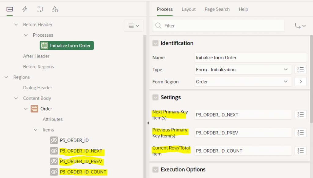
The page has a process before header of type Form – Initialization. This process has the following optional settings: Next Primary Key Item(s), Previous Primary Key Item(s), and Current Row/Total Item. To use this feature you must first create items (usually hidden) and then set these attributes to the item names.
Note that the Next / Previous Primary Key Item(s) attributes accept a comma-delimited list of items which allows them to support a compound key; I haven’t tested it but I expect this means it can support more than 2 columns.
The form will automatically populate these hidden items with the Order ID of the next and previous record, and will set the Current Row/Total Item to something like “8 of 10”. You can then use these items how you wish, e.g. as per the legacy pagination scheme, add the “Next” and “Previous” buttons, and create the navigation Branches to open the form with the relevant records.
To control the navigation order, you must set the Order By attribute on the form region. If this is not set, the navigation order is essentially unpredictable (APEX uses null as the sort order).
Same as the legacy pagination process, the form executes two queries: one to load the data for the form, and a second to gather the Next, Previous, Position and Count for the record, using SQL like this (I’ve simplified it a bit):
select i.*
from (
    select ORDER_ID, CUSTOMER_ID, ORDER_TOTAL, ...
           lead(ORDER_ID,1) over (order by ORDER_ID) as APX$NEXT_1,
           lag(ORDER_ID,1) over (order by ORDER_ID) as APX$PREV_1,
           row_number() over (order by ORDER_ID) as APX$ROWN,
           count(*) over () as APX$TOTAL
    from (
        (select /*+ qb_name(apex$inner) */
                d.ORDER_ID, d.CUSTOMER_ID, d.ORDER_TOTAL, ...
         from (select x.* from DEMO_ORDERS x) d
    )) i
) i where 1=1
and ORDER_ID=:apex$f1
It should be noted that the comments above about how concurrent record inserts and deletes by other users, and about report filters and sorting, also apply to the new form process.
In the past I built a system where it was important that the “Next” / “Previous” buttons should allow the user to navigate up and down the records exactly as shown in the report, respecting user-entered filters and sort order. The approach I took was to gather the IDs into a collection and pass this to the form when the user opened a record. I described the implementation and limitations of this approach in an older blog post which I expect still works today: Next/Previous buttons from Interactive Report results
A good question – how to load fairly largish GeoJSON documents into a Google Map in APEX?
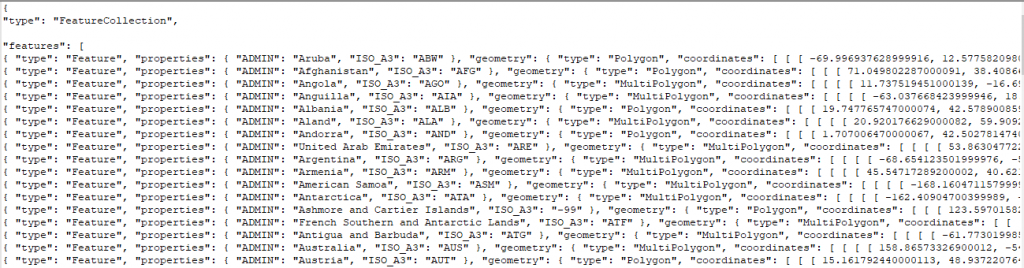
To investigate this I started by downloading a source of GeoJSON data for test purposes – one containing the borders of countries around the world: https://datahub.io/core/geo-countries. This file is 23.5MB in size and contains a JSON array of features, like this:
(the data does not appear to be very accurate for a lot of countries, but it will do just fine for my purposes)
Uploading the file to the database
To load this file into my database I copied the file to the server and ran this to load the data into a temporary table:
Alternatively, I could also have created a temporary APEX application with a File Browse item to upload the file and insert it into the import_lob_tmp table.
Parsing the JSON
I wanted to get the array of features as a table with one row per country; to get this I used json_table; after a fair bit of muddling around this is what I ended up with:
create table country_borders as
select j.*
from import_lob_tmp,
     json_table(the_clob, '$.features[*]'
         columns (
             country varchar2(255) path '$.properties.ADMIN',
             iso_a3 varchar2(255) path '$.properties.ISO_A3',
             geometry clob format json
         )) j;

alter table country_borders modify country not null;
alter table country_borders modify iso_a3 not null;
alter table country_borders modify geometry not null;
alter table country_borders add
    constraint country_border_name_uk unique (country);
alter table country_borders add
    constraint geometry_is_json check (geometry is json);
The first JSON path expression allowed me to drill down from the document root ($) to the features node; this is an array so I added [*] to get one row for each entry.
The COLUMNS list then breaks down each entry into the columns I’m interested in; each entry consists of a type attribute (which I don’t need), followed by a more interesting properties node with some attributes which are extracted using some relative JSON path expressions; followed by the geometry node with the GeoJSON fragment that represents the country borders that I wish to store “as is” in a clob column.
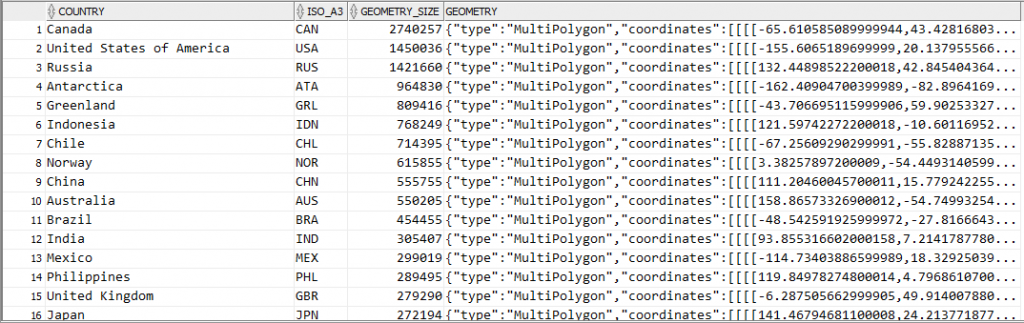
Now if I query this table it’s interesting to see which countries are likely to have the most complex coastlines (at least, as far as the data quality provided in this file will provide):
select country,
       iso_a3,
       dbms_lob.getlength(geometry) geometry_size,
       geometry
from country_borders
order by 3 desc;
It should be noted that since I’ve extracted the geometry node from each feature, the resulting data in the geometry column do not actually represent valid GeoJSON documents. However, it’s easy to construct a valid GeoJSON document by surrounding it with a suitable JSON wrapper, e.g.:
'{"type":"Feature","geometry":' + geometry + '}'
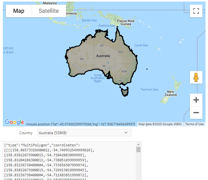
Showing the GeoJSON on a map
The next step is to load this border data onto a map for display. I recently released version 1.1 of my Report Map Google Map plugin which adds support for loading and manipulating geoJSON strings, so I started by importing region_type_plugin_com_jk64_report_google_map_r1 into my APEX application.
I created a page with a region using this plugin. I set the map region Static ID to testmap. On the same page I added a text item, P1_GEOJSON, to hold the GeoJSON data; and a Select List item P1_COUNTRY with the following query as its source:
select country
       || ' ('
       || ceil(dbms_lob.getlength(geometry)/1024)
       || 'KB)' as d
      ,country
from country_borders
order by country
I added a dynamic action to the Select List item on the Change event to load the geometry from the table into the map. Initially, I added the following actions:
A Set Value action that sets P1_GEOJSON to the result of the query: select geometry from country_borders where country = :P1_COUNTRY
An Execute JavaScript action that loads the GeoJSON into the map (after first clearing any previously loaded features):
This technique works ok, but only for smallish countries where the GeoJSON of their borders is less than 4K in size. For countries with more border detail than can fit within that limit, the Set Value action query only loads part of the JSON data, resulting in an invalid JSON string – and so the map failed to load it. The Set Value action was therefore unsuitable for my purpose.
To load the entire CLOB data I used another plugin. There are a few CLOB load plugins available for APEX – search the Plugins list at apex.world for “clob”. I chose APEX CLOB Load 2 by Ronny Weiß.
I imported the plugin dynamic_action_plugin_apex_clob_load_2 into my application, then replaced the Set Value action with the action APEX CLOB Load 2 [Plug-In]. I set SQL Source to:
select /* Element type dom - for jQuery selector e.g. body or #region-id,
          item - for item name e.g. P1_MY_ITEM */
       'item' as element_type,
       /* jQuery selector or item name */
       'P1_GEOJSON' as element_selector,
       geometry as clob_value
from country_borders
where country = :P1_COUNTRY
I set Items to Submit = P1_COUNTRY and Sanitise HTML = No. I also set Selection Type = Region and select the map region so that the spinner is shown while the data is loaded.
Result
The plugin works well. The border for any country can be loaded (for some countries, it takes a few extra seconds to load) and drawn on the map:
If you would like to see this in action, you may play with it here: https://jk64.dev/apex/f?p=JK64_REPORT_MAP:GEOJSON